

AMBER TRAIL
![]()
Poland, Slovakia, Hungary
BUDAPEST-KRAKOW-WARSAW, POLISH SECTION
Trail description
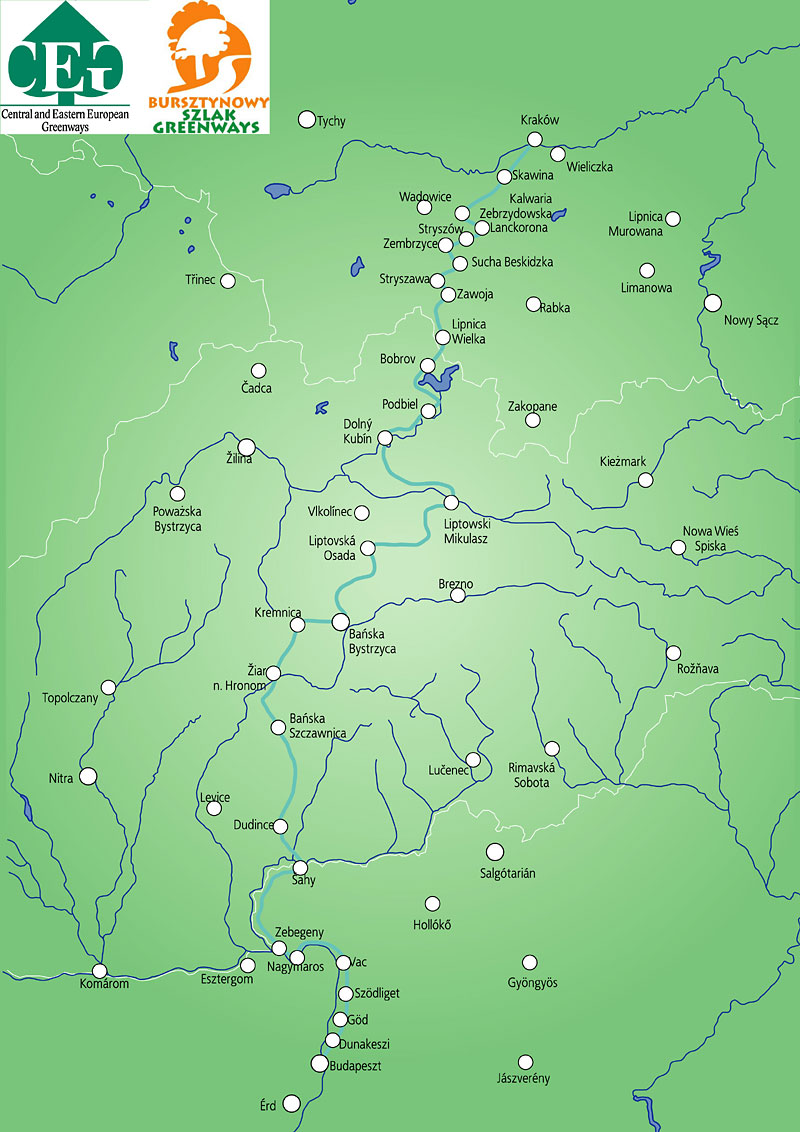
The Amber Trail Greenway is a trans-national trail running through Poland, Slovakia and Hungary. The greenway retraces the ancient route used for transporting amber from the Baltic to the Adriatic Sea, pioneered by the Celts and developed during the times of the Roman empire.
The Amber Trail Greenway links famous historical towns and UNESCO heritage sites (including Budapest, Banska Stiavnica, Krakow) with spectacular rural landscapes rich in natural and cultural values. The Amber Trail starts in Hungary, providing opportunities to explore the Danube and Ipel river valleys with the spectacular heritage towns of Szentendre, Vac and Nagymaros. Then the greenway leads through a diversity of landscapes and traditional architecture in the rural regions of Hungarian-Slovak border area, characterised by brick architecture and monumental gates guarding colourful houses overgrown with grapevine. Finally, it reaches northern Slovakia and southern Poland, with the carpathian wooden villages of Podbiel, Kvacany, Zubrzyca Wielka, Lanckorona. The Amber Trail connects people and places rich in cultural tradition, local heritage and delicious local cuisine.
Main tourist attractions and towns (nature and cultural heritage etc.)
Main villages / towns:
The greenway runs through small villages and towns, including Lipnica Wielka, Zawoja, Stryszawa, Zembrzyce, Stryszow, Kalwaria Zebrzydowska, Lanckorona, Wola Radziszowska, Radziszow, Skawina, Tyniec, Krakow, Krakow-Nowa Huta, Niepolomice. The border crossing with Slovakia is located in Lipnica Wielka - Bobrov.
Tourist attractions:
1. Lipnica Wielka (border crossing with Slovakia) - Krakow section - signposted
Babia Gora region -
a) Orawa: open air museum in Zubrzyca Gorna;
b) Babia Gora national Park and UNESCO Biosphere Reserve;
c) Environmental Education Centre on the Amber Trail in Zawoja-Przyslop;
d) Babia Gora shops in Stryszawa, selling local heritage products from the whole region;
e) Wooden toy workshops in Stryszawa;
f) Old Jewish inn "Karczma Rzym" in Sucha Beskidzka;
g) Renaissance castle surrounded by an old park in Sucha Beskidzka.
Stryszow -
a) The Stryszow manor - affiliated to the Wawel Castle Museum in Krakow;
b) The Stryszow Ecomuseum with numerous traditional roadside shrines.
Lanckorona -
a) The Lanckorona Ecomuseum;
b) Spectacular wooden architecture of Lanckorona and its medieval main square;
c) Amber Trail gallery and shop selling local heritage products.
Kalwaria Zebrzydowska -
Bernardine Monastery surrounded by a historic park with 42 small chapels (called Kalwaria Paths) - an UNESCO World Heritage cultural landscape.
Tyniec -
The ancient village of Tyniec dates back to 1044. It is the location of a spectacular Benedictine Abbey overlooking the Vistula River.
Krakow - the City of Polish Kings, UNESCO World Heritage Site
Krakow is the historic capital of Poland and was the seat of Polish kings. In its heyday in the 14th - 16th centuries, the city attracted great scholars and artists from across the world. The city's heritage reflects its connection to European culture. The most important sites include:
a) The largest medieval Market Square in Europe;
b) renaissance Wawel Royal Castle;
c) gothic St. Mary's Basilica;
d) historical trade pavilions called the Cloth Hall (Sukiennice);
e) Kazimierz - historic Jewish city;
f) Nowa Huta district - built as a garden city as part of a post-World War 2 socialist experiment and now absorbed into Krakow, which includes the Nowa Huta -Dlubnia Greenway (a local loop of the Amber Trail).
Krakow - Warszawa section- still under development, no signposts
Baltow region -
a) old mill in Baltow;
b) riding centre in Baltow
c) Jurassic Park in Baltow;
d) Turtle and Dinosaur Trail (a local loop of the Amber Trail).
The Kozienice Old-Growth Forest and Landscape Park -
a) industrial heritage park, narrow gauge railway in Pionki;
b) network of local trails in the old-growth forest ;
c) Zielonka near Warsaw - a green network of bicycle trails.
General characteristic of the Greenway
Geographical reference mark (major access points / start / end of a greenway)
Lipnica Wielka (border crossing with Slovakia) to Krakow section - signpopsted
- Length 139,6 km
- Surface:
a) Roads with high traffic: 1,1 km near Izdebnik
b) Roads with medium traffic: 27,1 km mainly near Zawoja
c) Quiet back roads: 54,4 km
d) Separate dedicated bicycle trail within the City of Krakow: 27,4 km
e) Forestry roads: Rajsztak 7,8 km and 2,0 km in the Babia Gora National Park
- Percentage of trail / forestry roads / service roads / quiet roads/ main trail or theme loop:
Main backbone:
(17%) - dedicated bike trails with no car access - in Krakow
(20 %) - forestry roads with hard surfaceo
(2 %) - unsurfaced forestry roads
(45%) - quiet roads
(16%) - roads with medium motor traffic
- Main users:
Main backbone: cyclists plus roller skaters and walkers in Krakow
Local loops: mountain bicycles, hikers, cross-country skiers, horse-carriage riders.
Local loops:
- Babia Gora region: Roadside Shrines Trail (20 km), Karol Wojtyla's educational trails, Cardinal Stefan Wyszynski's educational trails, Rocks and Beech Trees Trail, educational nature trails in Zawoja-Przyslop and others.
- Stryszow: a network of Amber Cycling Trails.
- Lanckorona: a network of local Amber Bicycle Trails, hiking paths around the Lanckorona Mountain, cross-country skiing loops, horse-carriage trail.
- Krakow: bicycle Tyniec trail along the Vistula River, Nowa Huta - Dlubnia Greenway in Krakow's Nowa Huta district.
- Swietokrzyskie region: The Turtle and Dinosaur Trail in Baltow.
- Pionki near Warsaw: narrow gauge railway managed by the „Lokomotywa" Local Partnership.
The Amber Trail is being extended to the Warsaw region through a connection to an established network of trails (350 km) in the Kozienice Old-Growth Forest, Radomka Valley, Janowiec, Baltow, Ilza, Otwock and Pinczow.
- Inter-modality possibilities (connections to closest cities / towns and options for using public transport train / bus with relevant web sites and links):
The nearest railway station to the border with Slovakia is Stryszawa (53,9 km). Other railway stations close to the trail: Sucha Beskidzka, Stryszow, Kalwiaria Zebrzydowska - Lanckorona, Skawina and Krakow (timetables available at www.pkp.pl)
Available maps and guidebooks
Maps:
The Amber Trail from Lipnica Wielka to Krakow (Compass Publishing House) in Polish and English; Around Babia Gora (Compass Publishing House) in Polish, available at www.compass.krakow.pl
Guidebooks about Lanckorona, Przyslop, Krakow's Nowa Huta and kazimierz districts published by the Bezdroza Publishing House, available at www.bezdroza.com
Map of the local loop in Baltow: The Turtle and Dinosaur Trail.
Contact to trail organization
Nina Galuszka, Amber Trail coordinator
Polish Environmental Partnership Foundation
(Fundacja Partnerstwo dla Środowiska), Bracka 6/6, 31-005 Krakow, Poland,
tel.: +48 12 422 50 88, faks: +48 12 429 47 25,
e-mail: greenways@epce.org.pl, www.szlakbursztynowy.pl
Contact available in Polish and English.